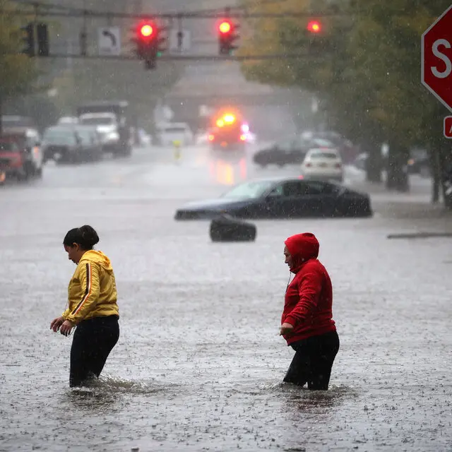
The NYC flash flood threat is the story tonight, and it is not going away quickly. A sluggish storm system is grinding its way across the Tri-State area, and the combination of heavy rainfall and saturated ground makes flooding the dominant concern into Wednesday morning.
Parts of the region have already absorbed staggering amounts of water. Areas of northwestern New Jersey have recorded close to ten inches of rain, a total that leaves the soil with nowhere left to put anything new. When ground reaches that point, additional rain does not soak in. It runs, and it collects in exactly the places drivers do not want to find it.
The Question Forecasters Are Watching
Multiple low-pressure centers developed south of the city Tuesday evening, and the precise track of the dominant one will determine how long the heaviest rain sits over New York.
There are two plausible paths, and they produce meaningfully different outcomes.
If the low tracks directly up the coastline, heavy rain would persist over New York City until roughly 4 or 5 a.m. before shifting north and east. That scenario also extends the downpours over the Hudson Valley deeper into the morning, adding hours of accumulation to an area already dealing with runoff.
The more likely path takes the system over central Long Island instead. In that case, the heaviest rain in the city should wind down by around 3 a.m., with the focus of the storm relocating north and east afterward.
Either way, the morning commute is going to be complicated.
What Wednesday Actually Looks Like
An AccuWeather Alert remains in effect for Wednesday morning, driven less by new storms than by the consequences of everything that has already fallen.
Lingering showers are expected, concentrated mostly north and east of the city. Conditions should improve gradually as the day progresses, with clouds beginning to break for periods of sunshine. A spotty shower or isolated thunderstorm is possible during the afternoon, but widespread heavy rain is not in the forecast beyond the morning hours.
That distinction matters. Wednesday is a cleanup day, not a repeat performance. The hazard is water already on the ground rather than water still falling from the sky.
Why Flooding Peaks After the Rain Stops
It sounds counterintuitive, but flooding often reaches its worst point after the heaviest rain has ended. There is a lag built into the system.
Rain that falls in the Catskills or the higher terrain of northern New Jersey does not immediately show up in local creeks. It moves downhill through smaller tributaries first, then into larger streams, and finally into rivers. That journey can take hours. A stream that looks manageable at midnight can be over its banks by sunrise, even under clearing skies.
Urban flooding follows a different but equally delayed pattern. Storm drains in dense areas handle a certain volume per minute. When rainfall exceeds that rate, water backs up at the lowest points — underpasses, highway dips, subway entrances, basement stairwells. Debris washed into grates during the peak of the storm can keep those drains blocked long after the rain has moved on.
The Commute Ahead
Anyone traveling Wednesday morning should build in extra time and expect the unexpected.
Roads that were passable at 5 a.m. may not be at 7 a.m. Standing water tends to appear in the same recurring locations across the region: low-lying stretches of parkway, service roads beside highways, and intersections at the bottom of hills.
A few practical points worth keeping in mind:
Do not drive through standing water when you cannot see the pavement beneath it. Depth is nearly impossible to judge from a driver’s seat, and roadway can be washed out underneath.
Roughly a foot of moving water is enough to float many passenger vehicles. Larger SUVs and trucks are less immune to this than their owners tend to assume.
If your car begins to be carried, abandoning it is safer than staying inside. Vehicles are the most common location for flood fatalities in the United States.
Barricades exist because someone assessed that stretch of road and closed it. Driving around one is a gamble against information you do not have.
Give yourself alternate routes before leaving rather than improvising while sitting in a flooded queue.
For Transit Riders
Rail and subway service can be affected even after surface conditions improve. Water infiltration into tunnels, signal problems caused by moisture, and debris on tracks all take time to resolve.
Checking service status before leaving home is worth the two minutes it costs. Delays announced at 6 a.m. are frequently different from the ones in effect at 8 a.m.
Around the House
For homeowners in areas that took the heaviest rainfall, particularly in northwestern New Jersey, the next day or two involves practical concerns.
Keep an eye on basements and sump pump operation, especially if power flickered overnight. Clear leaves and debris from gutters, downspouts and street drains near your property once it is safe to be outside, since blocked drainage extends flooding well past the storm itself.
Avoid contact with floodwater where possible. It routinely carries sewage overflow, fuel, and whatever chemicals were sitting in garages and sheds upstream.
The Broader Picture
Slow-moving systems like this one are the most efficient rain producers in the atmospheric toolkit. A fast storm dumps an inch and leaves. A stalled storm parks over the same watershed and delivers five, six, ten inches to ground that has no capacity left.
That is what happened in northwestern New Jersey, and it is why the region is dealing with genuine flooding rather than an inconvenient wet night.
The good news is that the pattern is finally breaking. By Wednesday afternoon, the sun should be making appearances and the atmosphere should be losing the moisture that fueled this. The rivers will take longer to settle than the sky will.
Until then, the safest approach is the simple one: slow down, leave early, and turn around when the road ahead is underwater.
Author
-
Lucienne Albrecht is Luxe Chronicle’s wealth and lifestyle editor, celebrated for her elegant perspective on finance, legacy, and global luxury culture. With a flair for blending sophistication with insight, she brings a distinctly feminine voice to the world of high society and wealth.