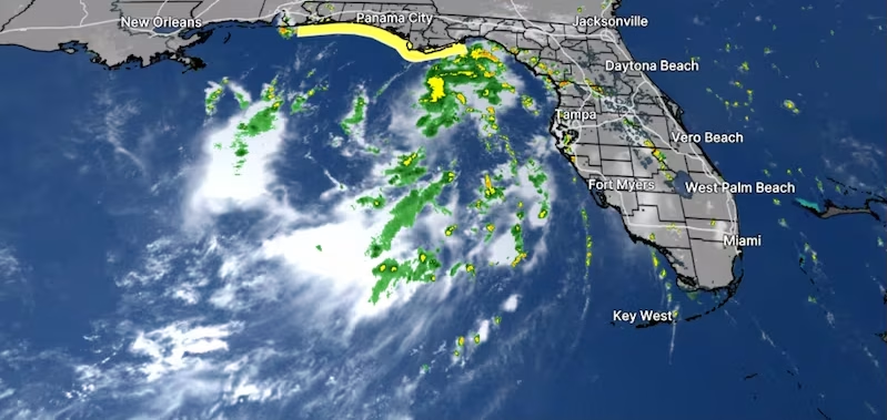
Tropical Depression Two Takes Shape Off Florida, Soaking Tampa Bay on Its Way West
Tropical Depression Two Florida forecasters had been watching finally organized on Sunday off the state’s west coast, and the National Hurricane Center expects it to earn a name shortly. If it strengthens as anticipated, it will become Tropical Storm Bertha — the second named system of an unusually quiet 2026 season.
The projected path takes it toward the northern Gulf Coast, with the Florida Panhandle sitting squarely in the zone of concern.
Where the System Stands
The hurricane center’s 5 p.m. Sunday advisory placed the depression’s center roughly 190 miles south-southeast of Panama City. Maximum sustained winds were clocked at 30 mph, and the system was barely moving at all.
That near-stall matters more than it might sound. A slow-moving tropical system dumps rain over the same ground for hours instead of passing through, which is how flooding problems develop even from storms that never reach hurricane strength.
Forecasters expect a gradual drift to the northwest or north-northwest over the next day or two before the system hooks westward and tracks near or along the northern Gulf coastline.
Tampa Bay Isn’t in the Path — But It’s Still Getting Wet
Here’s the part residents around Tampa Bay need to understand: the storm’s center is heading away from them, but the weather isn’t.
The system spent the weekend throwing bands of rain and thunderstorms across west Central Florida and Southwest Florida, and the National Weather Service in Tampa expects more of the same into the start of the work week.
Forecasters warned of rounds of gusty winds and heavy downpours, noting that some storms could turn strong enough to flood streets and low-lying areas. A marginal risk for excessive rainfall was flagged along the immediate west coast through Sunday night.
For anyone commuting Monday morning, that translates to standing water, poor visibility, and the usual intersections that flood every time.
What the Panhandle Should Expect
A tropical storm watch covers the Florida coastline from the Ochlockonee River west to the Alabama state line. Tropical-storm conditions could arrive within that zone by late Monday.
Key hazards outlined by forecasters:
- Storm surge of 1 to 3 feet along the Florida coast between Indian Pass and Chassahowitzka
- Rainfall totals of 2 to 4 inches through Thursday across the eastern and central Gulf Coast, stretching from western Florida into southern Alabama, Mississippi and Louisiana
- Isolated totals up to 8 inches in the heaviest bands
- Flash flooding as the primary threat across that entire corridor
Eight inches of rain in a few days is enough to overwhelm drainage systems well inland from the coast. The flooding risk here isn’t limited to beachfront communities.
How Strong Will It Get?
The hurricane center projected the depression would reach tropical storm status either late Sunday or Monday, with sustained winds building toward 60 mph by Wednesday morning.
That forecast comes with an unusual amount of hedging, though. Forecasters noted the system has a better shot at intensifying once it turns west, but how much it strengthens depends heavily on how far offshore the circulation stays.
They also acknowledged their track forecast sits toward the higher end of computer model guidance, with low confidence overall because of uncertainty about land interaction.
In plain terms: nobody knows yet how much of this storm will stay over warm water versus scraping the coast. Water fuels tropical systems; land tears them apart. A small shift either way changes the outcome considerably.
A Season That Started Slow
This is only the second named system of 2026. The first, Tropical Storm Arthur, formed in the Gulf back in June, lasted briefly, and brought flooding to parts of Texas and Louisiana before dissipating.
Bertha is next on the naming list, with Cristobal waiting behind it.
The Atlantic season opened June 1 and runs through November 30, though the genuinely active stretch typically arrives from mid-August through October. In other words, the calendar is only now approaching the period that historically produces the most activity.
Below-Normal Expectations
NOAA’s official outlook, issued in late May, calls for a quieter-than-usual year:
- 8 to 14 named storms
- 3 to 6 of those reaching hurricane strength
- 1 to 3 becoming major hurricanes at Category 3 or above
For comparison, an average season delivers 14 named storms, seven hurricanes and three majors.
It’s worth remembering what those numbers do and don’t mean. A below-normal season describes total activity, not individual risk. Plenty of destructive storms have arrived during quiet years. The forecast tells you how busy the season will be, not whether your particular stretch of coast gets hit.
What to Do Now
For residents along the Panhandle and northern Gulf Coast, the next 24 to 48 hours are the window for preparation rather than reaction. Secure loose outdoor items, check that drains and gutters are clear, and know whether your address falls in a surge-prone zone.
Around Tampa Bay, the guidance is simpler: expect an unsettled few days, allow extra time on the roads, and avoid driving through flooded streets no matter how shallow the water looks.
Forecast tracks shift. Watches get upgraded. Checking the latest advisory before making plans is the single most useful habit during any active system — and this one still has room to surprise people.
Author