An Albuquerque flash flood warning was in effect across much of the city Friday evening as monsoon storms stacked up overhead, sending fast-moving water surging through arroyos and prompting officials to alert residents in several neighborhoods and outlying communities.
Two separate warnings were issued as the storms built, covering different sections of the metro area and the terrain east of it.
Where the Warnings Applied
The first warning covered most of Albuquerque’s northeast side and was set to remain active until 8:30 p.m.
A second warning stretched across southeast Albuquerque along with Tijeras, the South Valley, El Cerro, Cedar Crest and Meadow Lake. That alert was scheduled to run until 9:15 p.m., giving it a slightly longer window as runoff continued moving downstream.
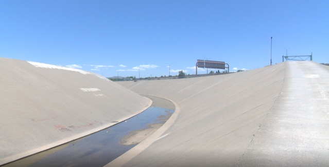
The most dramatic reports came from the city’s arroyos, the dry channels that thread through Albuquerque and normally sit empty for most of the year. Water in some of them was reported at depths exceeding eight feet.
Why Arroyos Turn Dangerous So Fast
For anyone unfamiliar with the desert Southwest, the speed of these events can be difficult to grasp. An arroyo can go from bone dry to a violent, chest-deep torrent in a matter of minutes, often while the sky directly overhead looks perfectly clear.
The reason is geography. Albuquerque sits in a basin surrounded by higher ground, including the Sandia Mountains to the east. When a storm parks over that higher terrain, rainfall does not soak into the ground the way it does in wetter climates. Desert soil is hard-packed and frequently hydrophobic, meaning it repels water rather than absorbing it. Urban surfaces make the problem worse, since pavement, rooftops and parking lots send nearly everything that falls straight into the drainage system.
All of that water funnels into arroyos, which act as natural and engineered channels carrying runoff down toward the Rio Grande. A person standing beside a dry arroyo bed may have no idea that a storm several miles uphill has already released a wall of water headed their way.
That is what makes these channels so deceptive. They look like convenient paths, shortcuts or places to ride a bike. During monsoon season, they can become lethal without warning.
The Difference Between a Watch and a Warning
The distinction matters more than most people realize when an alert appears on a phone screen.
A flash flood watch means conditions are favorable for flooding to develop. It is a signal to pay attention, delay unnecessary travel and think through your route home.
A flash flood warning means flooding is either happening now or is imminent in the area described. It is not advisory language. It is an instruction to move away from low-lying ground, drainage channels and any road that dips beneath grade.
Both of Friday’s alerts fell into the second category, which is why the reports of arroyos running eight feet deep carried so much weight.
The Advice That Saves Lives
Emergency managers across the Southwest repeat the same short list every summer, largely because the same preventable mistakes recur every summer.
Never drive into water covering a roadway. The depth is almost impossible to judge in the dark, and the pavement underneath may have already washed out. A relatively modest amount of moving water can lift a vehicle and carry it sideways, and larger vehicles offer far less protection than drivers assume.
Stay out of arroyos entirely during and after storms. That includes walking, cycling, letting pets run and taking photos from the edge. Bank collapse is a real hazard even when the water itself never reaches you.
Take barricades seriously. Road closures during flooding are placed for structural reasons, not convenience, and driving around them puts rescue crews at risk along with the driver.
Move to higher ground rather than waiting to see how bad it gets. Flash flood events peak quickly, and the window to relocate safely is often measured in minutes rather than hours.
Keep alerts enabled on your phone. Wireless emergency alerts are frequently the fastest notification anyone receives, particularly during evening hours when many people are not watching a broadcast.
Monsoon Season in New Mexico
Friday’s storms fit a familiar summer pattern. New Mexico’s monsoon typically runs from roughly late June into September, drawing moisture northward and producing afternoon and evening thunderstorms that can be intense but highly localized.
That localization is part of what catches people off guard. One neighborhood may record significant rainfall while another a few miles away stays completely dry. The runoff, however, does not respect those boundaries. Water generated over the mountains or the northeast heights travels through the drainage network into areas that may have received almost nothing.
The season is also essential. These storms supply a meaningful share of the region’s annual precipitation, feed vegetation and reduce wildfire risk. The same rainfall that fills arroyos is what keeps the landscape functioning. The danger lies in how the water arrives, not in the fact that it does.
Communities East of the City
The second warning’s coverage of Tijeras, Cedar Crest and surrounding areas reflects the added risk in canyon and foothill terrain. Steeper slopes accelerate runoff and concentrate it into narrow channels, and burn scars from previous wildfires can amplify the effect for years afterward by stripping away the vegetation that would otherwise slow water down.
Residents in those areas often have fewer road options as well, meaning a single flooded crossing can isolate a neighborhood until levels drop.
Staying Informed
Conditions during monsoon events change rapidly, and warning boundaries and expiration times are frequently updated or extended as storms develop. Residents should rely on the National Weather Service, local emergency management channels and official city updates for the current status rather than assuming an expired warning means the danger has passed.
Runoff can continue moving through arroyos well after the rain stops overhead. The safest assumption during monsoon season is that a channel with water in it stays dangerous longer than it looks.
Author
-
Lucienne Albrecht is Luxe Chronicle’s wealth and lifestyle editor, celebrated for her elegant perspective on finance, legacy, and global luxury culture. With a flair for blending sophistication with insight, she brings a distinctly feminine voice to the world of high society and wealth.