

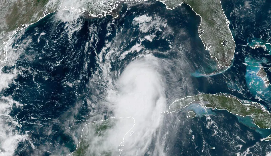
Tropical Storm Arthur is poised to become the first named storm of the 2026 Atlantic hurricane season, and forecasters warn that the bigger danger isn’t the wind — it’s the water. The system currently known as Potential Tropical Cyclone One is creeping along the Texas Gulf Coast and threatens to unleash life-threatening flooding across parts of Texas and Louisiana through the end of the week.
Where the Storm Stands
As of the latest advisory, the National Hurricane Center reports the system sitting roughly 25 miles southeast of Corpus Christi, Texas, drifting northeast at about 6 mph with maximum sustained winds near 30 mph.
The forecast path keeps the system close to the coast. Overnight, it is expected to slip farther offshore and travel roughly parallel to the upper Texas coast through Wednesday. From there, it should curve back inland over extreme eastern Texas or southwestern Louisiana on Wednesday night.
Once it drifts over the warm waters of the western Gulf, conditions favor strengthening. With sea surface temperatures in the mid-80s, the environment is ripe for development, and forecasters expect the system to organize into Tropical Storm Arthur as early as Wednesday morning once sustained winds reach 39 mph.
How Strong Will It Get?
Here’s the reassuring part: this is not expected to become a hurricane. The Fox Forecast Center notes that moderate wind shear and limited time over open water will cap how strong the system can become. Even in a worst-case scenario, forecasters don’t anticipate anything beyond tropical storm strength.
But weak winds don’t mean low risk. Regardless of how organized Arthur becomes, the flooding threat remains significant and potentially deadly along the Gulf Coast.
The Real Threat: Heavy Rain and Flooding
Rainfall is the headline concern. The system is forecast to dump heavy rain across a wide stretch of the region, with some areas potentially seeing up to a foot of water.
Communities likely to feel the heaviest impacts include Lake Charles, Lafayette, Baton Rouge, Alexandria, Covington, Hammond, New Orleans, Picayune, Hattiesburg, and Jackson. Residents in these areas should prepare for substantial rainfall over the coming days.
A breakdown of expected rainfall totals across parts of Louisiana and south Mississippi:
- Northshore and south Mississippi: 5 to 10 inches, with locally higher amounts
- River parishes and the metro area: 3 to 5 inches
- Bayou parishes and the coast: 1 to 3 inches
These figures can shift as the storm evolves, so staying tuned to local forecasts is essential.
Watches and Warnings in Effect
The National Hurricane Center has rolled out a series of alerts as the system approaches:
- A Tropical Storm Warning is in effect for the Louisiana coast from Sabine Pass to Morgan City, meaning tropical storm conditions are expected within 24 hours.
- A Tropical Storm Watch covers the northwestern Gulf coast from Sargent, Texas, to Sabine Pass, signaling that tropical storm conditions are possible within 12 to 24 hours.
- Storm surge of 2 to 4 feet is possible from Port Bolivar, Texas, to Morgan City, Louisiana.
A Flood Watch is also in place for much of the Northshore, the River Parishes, portions of the Bayou Parishes, and the metro area, remaining active through Friday morning.
What a Flood Watch Means
A Flood Watch indicates that conditions are favorable for flooding to develop. It’s not a guarantee that flooding will occur, but it’s a signal to prepare now if you live in a flood-prone area. Use the time to make a plan and be ready to act quickly if a Flood Warning is issued.
Timing the Impacts
Here’s how the next few days are expected to unfold:
Wednesday brings lighter showers in the morning, with hit-or-miss activity throughout the day. Rain becomes heavier in the evening and overnight as the system draws nearer.
Thursday is shaping up to be the wettest stretch, with the heaviest rain expected in the morning and additional downpours possible into the afternoon.
A notable wrinkle: Houston, despite sitting near the storm’s path, is forecast to largely miss the worst of it. The system is lopsided, and dry air pulling in behind the storm is expected to keep heavy rain focused on the eastern side. As a result, Houston may see only about an inch of rain, mostly falling Wednesday morning.
Staying Safe
The most important safety message during a flooding event is simple but lifesaving: never drive into floodwaters. More than half of all flash-flood deaths happen in vehicles that enter flooded roadways. If you’re traveling through the affected region, use extreme caution or postpone the trip altogether.
As Arthur takes shape over the Gulf, the days ahead will demand vigilance from residents across Texas, Louisiana, and Mississippi. The storm’s winds may stay modest, but its rainfall has the potential to turn dangerous fast. Keep an eye on updates from the National Hurricane Center and your local weather team as the forecast continues to refine.
Author