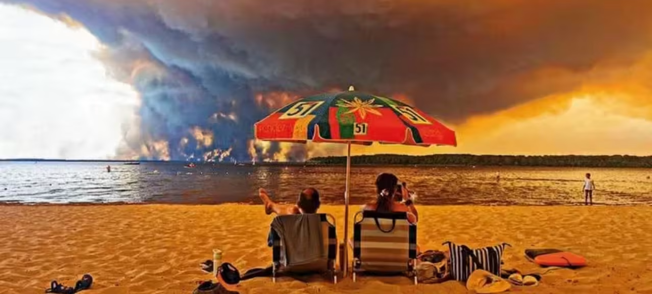
The France fire-cloud reported near Bordeaux over the weekend marks something the country has never officially recorded before, and fire scientists are treating it as a threshold moment rather than a curiosity. It arrived during a season that has already forced hundreds of thousands of people from their homes and battered the economy at the height of the tourist calendar.
What is unsettling researchers is not only how much land is burning. It is that the fires are behaving in ways France has not previously had to plan for.
What a Fire-Cloud Actually Is
The technical name is pyrocumulonimbus, and it describes a thunderstorm cloud born from a fire rather than from ordinary weather.
The mechanism is straightforward in principle. A large wildfire generates enormous heat. That heat pushes a column of smoke, ash and water vapour upward with tremendous force, carrying it far higher into the atmosphere than smoke normally travels.
David Bowman, professor of pyrogeography and fire science at the University of Tasmania, described it to Reuters using a simple image: think of a chimney, with fire at the base and smoke driven straight up and out the top, in this case reaching into the stratosphere.
Once that column climbs high enough, the moisture in it cools and condenses. The result is a cloud that looks and behaves like a storm system, complete with the capacity to produce lightning.
Why Forecasters Cannot See Them Coming
Meteorologists can identify the ingredients that make a fire-cloud possible. What they cannot do is say when or where one will actually form.
Jean-Christophe Vincendon, wildfire coordinator for the French national meteorological service, explained that favourable conditions can be recognised, but precise prediction is beyond current capability. That limitation matters operationally. Emergency planners can be told the risk exists without being told which fire, on which afternoon, will suddenly generate its own weather.
How They Make Fires More Dangerous
A fire-cloud is not merely a dramatic sight above a blaze. It actively changes the behaviour of the fire underneath it, in three distinct ways.
The first is wind. The violent updraft feeding the cloud pulls air inward at ground level, generating strong and shifting gusts. A fire that had been advancing predictably in one direction can turn, split, or accelerate. Crews positioned according to a known fire front can find that front somewhere else entirely.
The second is lightning. These clouds can discharge lightning the way ordinary thunderstorms do, and that lightning strikes ground that is often bone dry and covered in fuel. The consequence is new ignitions, sometimes well ahead of the main fire and beyond established containment lines.
The third arrives at the end. When the cloud exhausts the energy sustaining it, the column can give way in what fire scientists call a plume collapse. Bowman described the result plainly: everything the column was holding aloft comes down at once, a shower of burning debris raining over the area below.
That collapse is among the most hazardous moments for anyone working near a major fire, because it can seed ignitions across a wide radius in a matter of seconds and it offers essentially no warning.
The Bordeaux Sighting
French authorities confirmed on Saturday that a pyrocumulonimbus had been observed near Bordeaux, the first such record in the country’s history.
For emergency services, the practical consequence is that caution has to expand. Marc Vermeulen, who heads the Gironde fire and rescue service, said the erratic behaviour these events produce can force authorities to widen evacuation zones as a precaution, because the area at risk is no longer defined by where the fire currently is.
That is a significant operational shift. Evacuation planning normally works from fire perimeters, wind forecasts and terrain. A fire capable of throwing lightning several kilometres ahead of itself makes those calculations considerably less reliable, and the safe response is to move more people, sooner, over a larger area.
Why This Is Happening in France Now
Fire-clouds are not new to the planet. They have been documented repeatedly in Canada and Australia, where vast, continuous stretches of wilderness allow fires to reach the scale and intensity required to punch a column into the upper atmosphere.
Western Europe has historically lacked that combination. Landscapes are more fragmented, fires have tended to be smaller, and conditions rarely reached the extremes needed.
Bowman said that expectation should now be revised, and that Western Europe can anticipate seeing more of this phenomenon. The implication is that European fires are reaching intensities that were previously confined to other continents.
He was unambiguous about how to read it, calling the development a gravely serious milestone. He acknowledged the scientific interest in observing something new, while stressing that it is also disastrous, and that nobody wants more of them.
The Broader Season
The fire-cloud is one datum inside a much larger picture. France is contending with a fire season without precedent in its modern records, and the strain has spread across borders. Firefighting services in France and Spain have been scrambling to contain blazes with another heatwave approaching, and the scale of demand has pushed Europe’s aerial firefighting capacity to its limits.
Waterbombing aircraft are a finite resource. When multiple large fires burn simultaneously across several countries, the aircraft that would normally be redeployed to whichever fire is most threatening are already committed elsewhere. That constraint compounds every other problem on the ground.
What It Means Going Forward
The appearance of a pyrocumulonimbus over French terrain functions as evidence about conditions rather than as an isolated event. Fires generate their own weather only when they are burning hot enough and large enough to do so. The cloud is a symptom.
For France, the immediate task is containment and evacuation. The longer question is one of preparation: whether firefighting doctrine, evacuation planning and aerial resources built around a European fire regime remain adequate for fires that have started behaving like those in Canada and Australia.
Saturday’s observation near Bordeaux suggests that question is no longer theoretical.
Author
-
Lucienne Albrecht is Luxe Chronicle’s wealth and lifestyle editor, celebrated for her elegant perspective on finance, legacy, and global luxury culture. With a flair for blending sophistication with insight, she brings a distinctly feminine voice to the world of high society and wealth.