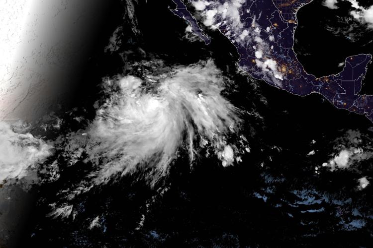
Tropical Storm Bertha flooding is proving that a storm’s danger zone and its location on a map are not always the same thing. Bertha itself is unraveling over the Gulf, a ragged and unimpressive system by tropical standards. Yet the water it lifted out of the ocean is now hundreds of miles inland, colliding with a stalled weather front and threatening communities that will never feel a single gust from the storm’s core.
It is a reminder that in tropical meteorology, the eye is rarely where the real trouble lives.
Where Bertha Actually Is
Early Thursday found the storm sitting south of Louisiana, lopsided and poorly organized, with sustained winds topping out near 45 mph. Its track carries it near or along the Louisiana and upper Texas coastlines through the afternoon before it pushes ashore over Texas by nightfall.
Forecasters expect Bertha to cling to tropical storm status until it reaches the upper Texas coast late Thursday, then fall apart over land by Thursday night or Friday.
Along the way, the Gulf Coast gets a fairly typical package of tropical nuisances:
- Wind gusts reaching tropical storm strength
- Dangerous surf and rip currents along beaches
- Rainfall of 2 to 4 inches, with pockets reaching 6 inches across the Texas coast and South Texas
- Scattered flash flooding where the heaviest bands linger
Meaningful, certainly. But not the headline.
The Real Story Is 800 Miles East
Bertha’s more consequential legacy is atmospheric rather than geographic. The storm has been pumping a deep river of tropical moisture northeastward, and that moisture is now feeding directly into a cold front stretched across southeast Virginia, the Carolinas, and northern Georgia.
That front is not going anywhere. It has stalled — and stalled fronts are how ordinary rainstorms become disasters.
The combination is straightforward and dangerous: a stationary boundary that keeps generating storms, plus an unlimited supply of tropical moisture to feed them. Rain falls repeatedly over the same drainage basins, hour after hour, until the ground gives up trying to absorb it.
A Region Already Saturated
None of this is arriving on dry ground.
The same weather system now parked over the Southeast is the one that produced historic flooding in West Virginia earlier in the week and battered a swath of territory from the Ohio Valley to the Atlantic coast. It will hang around Virginia and the Southeast through the end of the week.
Bertha’s moisture began pouring into that setup in earnest on Wednesday, essentially reloading a system that had already done considerable damage.
The results showed up quickly. Bands of rain developed across eastern Tennessee, southern Virginia, and northern North Carolina. Storms north of Knoxville triggered flash flood warnings Wednesday morning, with some locations recording up to 5 inches in a matter of hours.
The Drought Irony
Here is the cruel wrinkle: parts of southern Virginia and North Carolina genuinely need this rain. Drought has been a real problem there.
But rainfall is only useful when the ground has time to take it in. Deliver a month’s worth over three days and the deficit does not get erased — it gets replaced with a different emergency. Soil saturates, streams rise fast, and water that should have recharged aquifers instead runs across the surface looking for the lowest point.
Some areas in the flood zone are on track to receive exactly that kind of overwhelming total through Friday.
Reading the Risk Levels
Forecasters have flagged a Level 3 of 4 excessive rainfall risk along a stretch of the Virginia–North Carolina border from Thursday into Friday morning. That designation signals a genuine likelihood of flash flooding, not a remote possibility.
Thursday afternoon brings the sharpest edge of the threat. Thunderstorms are expected to produce rainfall rates approaching 2 inches per hour — an intensity that outruns storm drains almost immediately and turns city streets into channels.
Cities in the crosshairs include:
- Atlanta, Georgia
- Birmingham, Alabama
- Charlotte, North Carolina
Urban areas are particularly vulnerable to these rates. Pavement absorbs nothing, and drainage infrastructure designed for typical summer downpours simply cannot move that volume fast enough.
Friday Keeps the Pressure On
The threat does not conveniently end when the calendar flips. A Level 2 of 4 risk extends Friday from coastal North Carolina through South Carolina, across northern Georgia, and into northeastern Alabama.
Portions of that zone may be upgraded to Level 3 as models sharpen their read on where the heaviest bands will ultimately anchor. That uncertainty is normal at this range — pinpointing the exact axis of extreme rainfall more than a day out remains one of the harder problems in forecasting.
A Quiet Season, So Far
Bertha holds the distinction of being just the second named system of the Atlantic hurricane season, a notably sluggish pace compared with recent years. El Niño conditions have tightened their influence over portions of the basin, and that pattern typically suppresses tropical development through increased wind shear.
A slow season is welcome news. It is also not a guarantee of anything. Individual storms do not consult the seasonal outlook before forming, and as Bertha is currently demonstrating, a modest system can still create serious problems well beyond its own footprint.
What This Means If You’re in the Path
The practical advice is unglamorous but genuinely lifesaving. Flash flooding kills more people through vehicles than almost any other mechanism, and the reason is depressingly consistent: drivers underestimate moving water.
Keep a few things in mind through Friday:
- Never drive into water covering a roadway, regardless of how shallow it appears
- Stay alert to warnings overnight, when flooding is hardest to see and most lethal
- Avoid low-lying roads, underpasses, and creek crossings during heavy bands
- Remember that clearing skies overhead do not mean upstream runoff has passed
Bertha will be a memory by Friday, dissolved somewhere over Texas. The water it carried east will still be finding its way downhill — and that, not the storm itself, is what this week will be remembered for.
Author
-
Lucienne Albrecht is Luxe Chronicle’s wealth and lifestyle editor, celebrated for her elegant perspective on finance, legacy, and global luxury culture. With a flair for blending sophistication with insight, she brings a distinctly feminine voice to the world of high society and wealth.