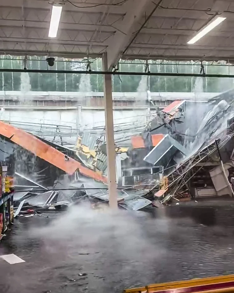
The tri-state area flooding has turned dangerous and destructive, with New Jersey bearing the brunt of a relentless storm system that has left communities scrambling. In one of the most striking scenes, a BJ’s Wholesale Club roof buckled under the weight of the downpours, sending water cascading through the store’s aisles as shoppers watched in disbelief.
A Region Under Siege
After nearly a week of oppressive, stifling heat, the tri-state region has swung dramatically to the opposite extreme. A slow-moving yet powerful storm system rolled in Sunday night and refused to let up, continuing to batter the area throughout Monday.
New Jersey found itself in the crosshairs, absorbing punishing rainfall that threatened to overwhelm infrastructure across the state. The intensity of the precipitation raised serious concerns, particularly for New York City’s vulnerable subway system, which faced the possibility of flooding as rain fell at alarming rates.
Dramatic Damage Caught on Camera
Perhaps the most memorable image from the storm came from a BJ’s Wholesale Club, where the roof partially collapsed amid the heavy rain. Video and photos captured the unsettling moment as water poured into the store, flooding the chip aisle and turning a routine shopping trip into a scene of chaos.
Remarkably, despite the dramatic nature of the collapse, the situation could have been far worse. The footage served as a vivid reminder of just how much water the region was contending with and the real-world consequences of such extreme weather.
What Residents Needed to Know
As the storm intensified, officials and forecasters issued a series of critical warnings to help residents stay safe. The key concerns included:
- Additional rough weather was expected to slam the tri-state area through Monday night, with rainfall rates reaching up to 3 inches per hour at times. Such intensity posed major threats to both transit systems and power infrastructure.
- Flash flood warnings began appearing across New York City, parts of New Jersey, and areas on Long Island before noon.
- New Jersey appeared especially hard hit early in the day, with major flash flooding reported along the Jersey Shore.
- The storm arrived on the heels of a third consecutive day of severe weather, some of which had already unleashed hurricane-force gusts on parts of Long Island.
These overlapping hazards created a challenging and potentially dangerous situation for millions of people throughout the region.
City Leadership Responds
In New York City, newly relevant leadership stepped forward to address the growing threat. Mayor Zohran Mamdani urged residents to prepare for the potential of flash flooding and to take the situation seriously.
His guidance to New Yorkers was practical and direct. He suggested that people limit their travel on Monday if at all possible, plan ahead for delays, and pay close attention to official weather alerts. This kind of proactive messaging aimed to keep residents out of harm’s way as conditions deteriorated.
Transit Systems on High Alert
The storm placed significant strain on the region’s transportation networks. NJ Transit had already experienced storm-related impacts, signaling trouble for commuters trying to navigate the flooded landscape.
The New York City subway system faced its own precarious situation. Officials noted that the subway is designed to handle up to 1.75 inches of water per hour. However, a rate of 2 inches per hour could overwhelm the system and lead to flooding. With rainfall rates climbing as high as 2 inches an hour in some areas, the margin for error was dangerously thin.
Lingering Threats From Previous Storms
The current deluge didn’t arrive in isolation. It followed several consecutive days of stormy weather that had already left their mark on the region.
Some of those earlier storms brought hurricane-force gusts to parts of Long Island, knocking down trees in the process. This created an additional complication: fallen debris could clog drains and sewers, worsening the flooding and making it even harder for water to drain away. The cumulative effect of days of severe weather compounded the risks facing communities.
Mounting Rainfall Totals
The numbers behind the storm underscored its severity. Forecasters warned that isolated rainfall totals could top 4 inches by the end of the day, an amount capable of causing widespread flooding and disruption.
Meanwhile, cleanup efforts from the weekend’s storms remained ongoing even as new rain continued to fall. This left residents and emergency crews juggling recovery from past damage while simultaneously bracing for fresh challenges, a difficult position that stretched resources thin.
The Broader Picture
What makes this weather event particularly notable is the dramatic contrast it presents. The tri-state area transitioned rapidly from a prolonged period of intense heat to a soaking, flood-prone deluge. This kind of whiplash weather pattern can catch communities off guard and strain infrastructure that must suddenly cope with entirely different conditions.
The slow-moving nature of the storm system proved especially problematic. When storms linger over an area rather than passing through quickly, they dump enormous amounts of rain in concentrated locations, dramatically increasing the risk of flash flooding. That appears to be exactly what unfolded across New Jersey and neighboring areas.
Staying Safe and Informed
For those living in the affected regions, the emphasis remained squarely on safety and preparedness. Checking local weather alerts became essential, as conditions could change rapidly from one neighborhood to the next. Flash flood warnings, in particular, demanded immediate attention, since floodwaters can rise quickly and turn ordinary roads into hazardous waterways.
Limiting unnecessary travel, planning for transit delays, and heeding official guidance all played a role in helping residents weather the storm. In situations like this, taking warnings seriously can make a meaningful difference in keeping people out of danger.
Final Thoughts
The powerful storm system that swept through the tri-state area delivered a forceful reminder of nature’s unpredictability. From the striking collapse of a BJ’s roof to widespread flash flooding along the Jersey Shore and the looming threat to New York City’s subways, the event tested the region’s resilience on multiple fronts.
As New Jersey absorbed the heaviest blows and Long Island contended with lingering effects from earlier storms, the entire region remained on edge. With rainfall totals climbing and additional rough weather forecast through the night, communities braced for whatever came next.
Ultimately, this stretch of turbulent weather highlighted the importance of preparation, communication, and caution. While cleanup from the weekend storms continued and new challenges emerged, residents across the tri-state area were left hoping for a break in the relentless rain, and a chance to recover from a truly chaotic weather event.
Author