Hurricane Lala rainfall totals have now been calculated, and the figures are staggering: roughly 1.3 trillion gallons of water fell across the Hawaiian Islands during a three-day stretch in August, according to researchers at the University of Hawaii at Manoa.
To put that volume in perspective, it would fill close to two million Olympic swimming pools.
A Storm That Never Actually Arrived
What makes the numbers remarkable is that Lala never came ashore. The system tracked south of the islands between Aug. 14 and Aug. 16, remaining offshore the entire time while still delivering punishing rain and destructive winds.
University researchers described the close approach past Hawaii island, where Lala was operating at Category 1 strength, as among the most consequential tropical cyclone events the state has experienced in decades.
That assessment underscores a point often lost in hurricane coverage. Landfall grabs headlines, but the rain shield and outer bands of a storm passing nearby can inflict comparable damage, particularly across steep island terrain.
Where the Water Fell
The distribution was heavily lopsided. Hawaii County absorbed about 66% of the statewide total, receiving roughly 833 million gallons on its own, equivalent to approximately 1.2 million Olympic pools.
Rainfall accumulations elsewhere on Aug. 16 were smaller but still substantial:
Maui County recorded 6.6 inches, amounting to 134 million gallons
Honolulu County recorded 5.5 inches, or about 57 million gallons
Kauai County recorded 3.1 inches, roughly 29 million gallons
The Extremes on the Big Island
Two measurements from Aug. 15 stand out.
At the Laupahoehoe station in Hamakua on Hawaii island, gauges logged a daily maximum of 32.1 inches. That figure exceeds what many mainland cities receive in an entire year, delivered in a single day.
Upslope of Naalehu, the Kaiholena station registered 24.4 inches. Within that total sat the event’s most intense burst anywhere in the state: 4.4 inches falling between 7:30 and 8:30 p.m., the highest hourly rate observed during the storm.
Rain arriving at that pace overwhelms soil absorption almost immediately, sending water racing downhill rather than soaking in.
Wind Damage Alongside the Flooding
Rain was not the only hazard. Instruments captured gusts reaching 80 mph at Puuloa in Kohala, and 79 mph on Haleakala on Maui.
Researchers cautioned that these represent only what stations happened to record. In areas lacking monitoring equipment, particularly along exposed ridges and slopes, actual gusts were likely stronger.
Naalehu Bore the Worst of It
The community of Naalehu on Hawaii island emerged as one of the hardest-hit locations.
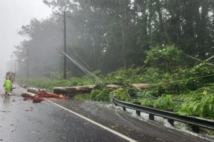
Flash flooding there was violent enough to shove homes off their foundations. Roads and bridges sustained damage, and entire neighborhoods found themselves cut off as access routes became impassable.
For residents, the aftermath involves not just repairing structures but restoring the basic connections that make daily life possible.
How the Data Was Gathered
These measurements came from the Hawaii Mesonet, a statewide network of monitoring stations operated by the university, along with the Hawaii Climate Data Portal. The Mesonet added a real-time public dashboard last year, allowing conditions to be tracked as they develop rather than only reconstructed afterward.
That capability proved valuable during Lala, when conditions varied dramatically over short distances.
Why Dense Monitoring Matters in Hawaii
Tom Giambelluca, who directs the Hawaii Mesonet, explained why granular measurement is essential in the islands specifically.
He noted that Hawaii’s terrain can convert a single storm into a modest two-inch event in one valley while producing forty inches just a few miles away. Without a tightly spaced network of stations, he said, there would be no way to capture that variation or accurately reconstruct what actually occurred.
That observation gets at something fundamental about island meteorology. Mountains force air upward, wringing moisture out of it on windward slopes while leaving leeward areas comparatively dry. A forecast averaged across an island tells residents very little about what to expect at their own address.
The Broader Lesson
Lala offers a case study in how tropical systems threaten communities even when the storm center stays offshore.
Steep topography accelerates runoff, funneling enormous volumes of water into narrow drainages within minutes. Communities positioned at the base of those drainages face risk regardless of where the eye tracks.
The event also highlights the practical value of investment in monitoring infrastructure. The detailed record now available will inform flood mapping, infrastructure planning and emergency response for future storms.
For Naalehu and other affected areas, recovery will continue well after the numbers stop making news. But the data collected during those three days provides something useful: a precise account of what a near-miss hurricane can do to an island chain, and a baseline for preparing before the next one passes by.
Author