UN Votes to Redraw the World Map So Africa Finally Looks Its Real Size
The Correct the Map resolution passed the United Nations General Assembly on Friday by a margin that left little room for ambiguity: 164 in favour, one against, six abstentions. The lone opposing vote came from the United States.
Togo brought the measure forward on behalf of the African Group — the 54 African member states at the UN — with backing from the African Union. Its aim is straightforward: to push the world toward maps that show Africa at its actual proportion relative to everywhere else.
Why a Map Became a Diplomatic Question
Speaking before the vote, Togo’s Foreign Minister Robert Dussey argued that maps do work far beyond marking coastlines and borders. They shape how people understand the world, he said, feeding into education, fuelling imagination, and steering collective perception.
He framed the effort as one Africa could undertake for itself, describing it as a matter of taking responsibility for what is within reach to change.
That framing matters. Nothing about the resolution forces anyone’s hand.
What the Resolution Does and Doesn’t Do
This is a non-binding measure. No government, publisher, or school system is required to retire the Mercator projection, which has anchored classroom walls and atlases for centuries.
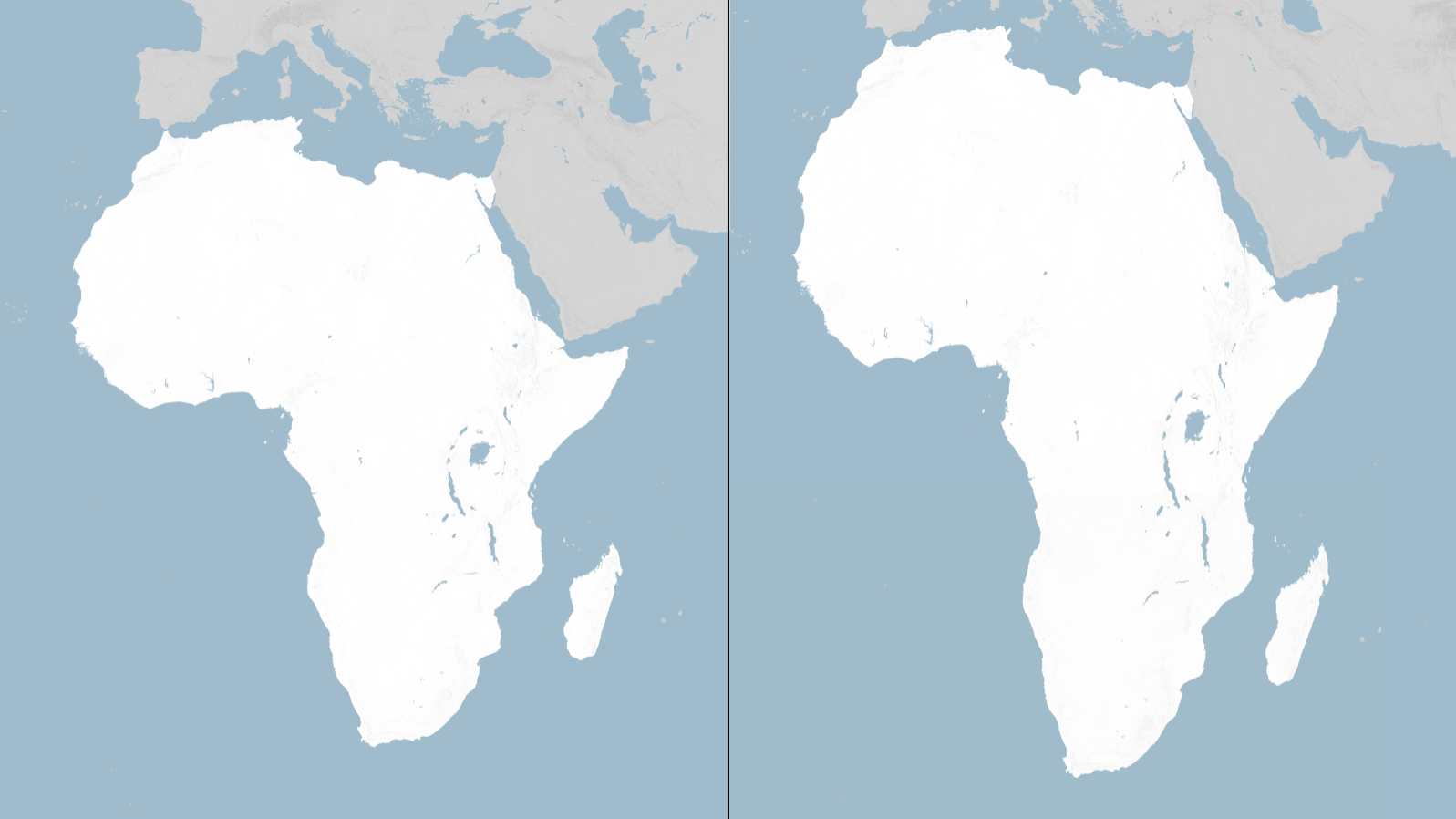
What it does instead is encourage adoption of equal-area projections — chief among them Equal Earth — which preserve accurate relative size at the cost of some distortion in shape.
Campaigners behind Correct the Map are now pressing governments, international bodies, and educational institutions to make the switch voluntarily.
The Problem With Mercator
Gerardus Mercator, a Flemish cartographer, produced his projection in 1569. He was not trying to make a general reference map of the world.
He was solving a navigation problem. His design let sailors draw a straight line between two points and follow a single compass bearing the entire way — an enormous practical advantage in the age of maritime exploration, and the reason the projection endured.
The trade-off is size. Mercator keeps shapes intact but stretches landmasses progressively as they approach the poles. Regions far north or south balloon well beyond their real dimensions, while territory near the equator shrinks by comparison.
Africa sits astride the equator. It is the continent most consistently underrepresented by the projection.
What Cartographers Say About Classroom Use
Tom Patterson, previously a senior cartographer with the U.S. National Park Service, put the issue plainly in a past interview. Used as a general world map in a classroom, he said, Mercator leaves students with a thoroughly distorted sense of how large countries actually are.
Patterson co-created Equal Earth in 2018 alongside Bernhard Jenny and Bojan Šavrič. The projection was built specifically to render landmasses in correct proportion to one another.
He reacted to the UN vote with evident surprise, writing that when the three of them designed the projection eight years ago, nothing like this had crossed their minds.
The American Objection
The United States did not simply abstain. It voted no and explained why in unusually sharp language.
Yaryna Ferencevych, deputy U.S. representative to the UN Economic and Social Council, said in a statement that the resolution reflected an ideological agenda and diverted attention from more urgent matters. She described measures of this kind as barnacles on the institution’s work and tied them to its declining credibility.
No other country joined that position.
Reaction From Africa
The African Union welcomed the outcome, saying the resolution advances equal-area maps such as Equal Earth in classrooms, media, and international institutions so that the world map reflects Africa’s genuine scale and standing.
Carlos Lopes, a professor at the University of Cape Town and one of the campaign’s most visible advocates, called the result an emotional moment, noting the 164-vote total.
Just How Distorted Is It?
The scale of the discrepancy tends to surprise people who have never seen the comparison.
Africa covers roughly 30 million square kilometres. On a standard Mercator map, Greenland — about 2.2 million square kilometres — appears comparable in size. In reality, Africa is around fourteen times larger.
Similar effects apply elsewhere:
- Canada and Russia both appear substantially inflated.
- Scandinavia looks far larger relative to equatorial nations than it is.
- Countries such as India, Indonesia, and Brazil appear diminished.
The Case Against Switching
Equal Earth is not without cost. Preserving area means sacrificing something else, and what it sacrifices is shape fidelity. Coastlines curve in ways that look unfamiliar to anyone raised on Mercator, and continents appear subtly compressed at their edges.
Cartographers have long accepted that no flat map can be simultaneously accurate in area, shape, distance, and direction. Every projection chooses its priorities. The argument here is about which priority belongs on a general-purpose reference map.
Mercator also retains genuine utility. Its constant-bearing property is why online mapping services still use a variant of it for street-level navigation.
Why This Vote Landed
The resolution changes no law and compels no institution. Its influence, if it has any, will operate through textbook publishers, ministries of education, and the design decisions of international organizations.
But the vote count is difficult to dismiss. A near-unanimous General Assembly has stated that how the world is drawn carries weight — and that a continent of 1.4 billion people has grounds to object when the default picture makes it look smaller than it is.
Whether that translates into new maps on classroom walls is now a matter for individual governments to decide.
Author