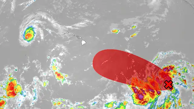
Tropical Storm Moke has not formed yet, but forecasters expect it to by the time the system tracks south of the Big Island this weekend. It currently exists as Tropical Depression Two-C, and it is heading toward communities that were flattened less than a week ago.
That timing is the whole problem.
Not a Repeat of Lala, but Not Harmless
John Bravender, warning coordination meteorologist at the Central Pacific Hurricane Center, was direct about the comparison during a Thursday press conference.
This is not the same as Lala, he said. The track appears to run further south and the wind field is smaller.
That is genuinely better news. It is also not the reassurance it might sound like.
The system currently carries sustained winds of 35 mph and sits roughly 815 miles east-southeast of Hilo, moving north-northwest at 14 mph. Strengthening is expected over the next two days, though forecasters anticipate it topping out as a high-end tropical storm rather than reaching hurricane strength, which requires sustained winds of at least 74 mph.
Why Weaker Still Means Dangerous
The concern is not the storm’s raw power. It is what the storm will land on.
Hurricane Lala damaged or destroyed a reported 263 homes and 18 businesses and killed two people on Hawaiʻi Island. Repairs are underway everywhere. Debris remains. Slopes have already failed.
Bravender explained the compounding risk plainly. Even with smaller rainfall totals, given the damage already sustained and the repairs people are still attempting, he said forecasters are concerned about additional damage potential.
The ground is the specific worry. Hawaiian soils are porous and drain quickly, but they remain wet and saturated. Additional rain arrives with nowhere to go.
More flooding damage is what forecasters are watching for, he said.
The Rainfall Numbers
According to the 5 a.m. Thursday advisory from the National Hurricane Center, heavy rain will reach the Big Island late Saturday night before spreading west to the other islands Sunday into Monday.
Expected totals:
- Big Island: 5 to 10 inches, with maximums near 15 inches
- Remaining Hawaiian Islands: 1 to 3 inches, with maximums near 5 inches
The greatest potential falls on windward and southeastern sections of Hawaiʻi Island, where 10 to 15 inches over the weekend is possible.
The Hurricane Center warned that this rainfall may produce life-threatening flooding and mudslides, particularly in steep terrain and in areas recently affected by Lala.
Wind and Surf
Terrain will shape the wind impacts as much as the storm itself.
Bravender described the setup as functioning like an enhanced trade wind pattern, with strong gusty winds concentrated in the areas that typically experience them. Local terrain can accelerate those gusts to damaging levels.
Swells generated by the system will reach parts of the islands this weekend, potentially creating life-threatening surf and rip current conditions. Forecasters noted that wind and wave impacts remain a risk regardless of the exact track, and that watches could be required for portions of the islands.
The Governor’s Preparations
Governor Josh Green described a situation still actively deteriorating from the previous storm.
Flooding and mudslides already exist and will continue evolving into a problem, he said. Nobody remains in the houses already covered with mud, but he could not rule out further effects on schools or on the Kaʻū hospital, which is currently open and functioning. Power restored to some residents could be lost again.
That uncertainty is driving the response. The state plans to pre-position extra resources and move some people out of affected communities ahead of the storm.
Green said support will be available, with philanthropic groups assisting. Residents may be housed in hotels in Hilo or Kona, and donated Airbnb accommodations are available for people facing power loss or worried about further terrain changes.
Leave Early, Not Late
Bravender’s most urgent message concerned timing.
His worry, he said, is people going through this again, which is why the messaging is being pushed hard for this type of cyclone. His instruction was to take action now, just in case, because escape routes and exits could be blocked or unavailable when they are needed.
Anyone in a flood-prone area should leave early and stay with friends or family. He urged people to think about that arrangement now, before the rain begins this weekend.
That advice reflects a hard lesson from Lala. Roads that exist during preparation may not exist during the storm.
Civil Defense Guidance
The Hawaiʻi County Civil Defense Agency issued specific instructions for residents and businesses:
- Prepare for damaging winds, flooding rains, high surf, worsening power outages, communication loss and road closures
- Check emergency kits for adequate food, water, medication, fuel, flashlights with working batteries and emergency contact information
- Secure outdoor items that could become airborne
- Boat owners and shoreline property owners should prepare for high surf
- Sign up for Civil Defense alerts by texting HawaiiAlerts to 888777
- Avoid unnecessary travel into the Kaʻū District to allow faster emergency response
About the Name
The system will be called Moke once it reaches tropical storm strength in the Central Pacific. The name is a commonly used Hawaiian equivalent of Moses, appearing throughout historical records and family genealogies.
Two More Systems Being Watched
Forecasters are tracking additional activity elsewhere in the basin.
One tropical wave sits a few hundred miles south of southern Mexico, producing gusty winds and disorganized storms. Conditions favor gradual development, and a tropical depression is likely to form this weekend or early next week as it moves west-northwest.
A second disturbance, a weak low several hundred miles south of Baja California’s southern tip, is generating a broad area of disorganized weather. It carries a 40 percent chance of development over the next seven days.
The Bottom Line
Green expressed hope the storm tracks far enough south to limit its effects.
Hope is not the plan, though. With this volume of water arriving on ground that cannot absorb it, Tropical Storm Moke threatens to turn a recovery into a second emergency, and the window to prepare closes Saturday night.
Author