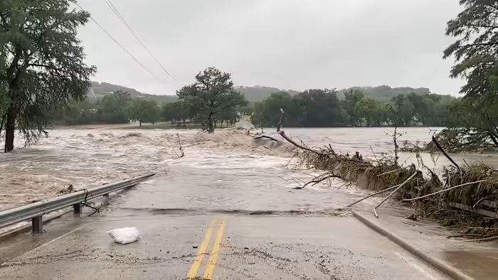
Texas flooding has reached a dangerous new peak as another round of slow-moving storms hammers already saturated parts of central and southwest Texas, pushing an exhausted region to the brink of life-threatening flash floods. With the ground already soaked and more heavy rain on the way, forecasters are warning that the coming days could bring catastrophic conditions.
A Region Already Underwater
The relentless downpours have triggered dozens of water rescues across the region, and meteorologists caution that the worst may not be over. Much of the danger is concentrated in areas that can least afford more rain, including Texas Hill Country.
That area carries painful recent memories. Just last July, devastating flash flooding tore through the Hill Country, killing more than 130 people, among them 25 girls and two counselors at Camp Mystic. The prospect of history repeating itself has put residents and officials on high alert.
By the end of Tuesday, the toll of the current storms was already mounting. At least 45 people had been pulled from floodwaters in Uvalde County, with additional rescues carried out in neighboring Medina County. Texas Governor Greg Abbott responded by issuing a disaster declaration covering 59 counties.
A Rare and Ominous Warning
The severity of the situation is underscored by an unusual alert from the Weather Prediction Center. Wednesday marked the second consecutive day the agency issued its highest risk of flooding rain, the first time it has done so on back-to-back days since April 2025.
Forecasters described the unfolding pattern in stark terms. Because storms keep striking the same areas repeatedly, the Weather Prediction Center called it a “worst-case scenario” for flooding.
Why the Threat Is So Severe
The heightened danger stems from rounds of heavy, slow-moving rainfall falling on ground already soaked by 6 to 12 inches of rain on Monday and Tuesday. With storms dropping 2 to 4 inches of rain per hour, the threat of catastrophic flooding is expected to persist until Friday.
The saturated ground only makes things worse. With the soil unable to absorb more water, rain quickly turns to runoff, meaning it takes far less rainfall to trigger serious flooding. Several factors make this situation especially dangerous:
- Flooding could begin faster than usual because the ground is already soaked.
- The areas most at risk Wednesday closely mirror those deluged on Tuesday, including the western Hill Country, the Edwards Plateau, and the Rio Grande Valley near the US-Mexico border.
- Surrounding regions face a very serious Level 3 of 4 flood risk.
Flood watches are in effect for more than six million people across central and southwest Texas, including Austin, Del Rio, San Angelo, and San Antonio. The center warned that flooding is likely on roads and in urban areas, that some homes could be inundated, and that creeks, streams, and rivers will rise, with moderate to major flooding possible in some spots.
Staggering Rainfall Totals
The numbers paint a sobering picture. Rainfall totals could climb into the double digits in areas hit repeatedly since the rain began earlier in the week.
While the zone of greatest flash flooding risk will shrink somewhat by Thursday, it will still include some of the hardest-hit areas, stretching from Del Rio to Midland and San Angelo. Farther east, the threat extends toward the Gulf Coast, where Houston could see at least localized flooding. Conditions are expected to ease considerably by Friday, with a lower-level flood threat lingering mainly in the western part of the state.
By week’s end, parts of central and southwest Texas could see several additional inches of rain, with some of the hardest-hit locations potentially reaching up to 15 inches. The context makes these figures even more alarming. Del Rio could receive over 6 inches, roughly what the city typically sees across the entire June-to-August period, while totals around 10 inches would amount to half its average annual rainfall in just a few days.
Why This Keeps Happening
Extreme rainfall events like this are growing more frequent as planet-warming pollution drives temperatures higher. Warmer air holds more moisture, which storms can then wring out like a saturated sponge in intense, localized downpours.
The geography of the Hill Country compounds the problem. Its steep slopes, shallow soils, and exposed bedrock repel heavy rain rather than absorbing it, funneling water into fast-rising floods. Adding fuel to the current threat is a collision of abundant Gulf moisture with a stalled front and a pocket of upper-atmosphere energy, a combination notorious for producing slow-moving clusters of storms capable of unleashing 2 to 4 inches of rain an hour.
Staying Safe in the Days Ahead
As the storms continue, the message from officials is one of caution and vigilance. With floodwaters rising quickly and more rain on the way, residents across the affected counties face several dangerous days before conditions finally begin to ease. For a region still healing from last year’s tragedy, the hope now is that preparation and swift action can prevent another devastating loss.
Author