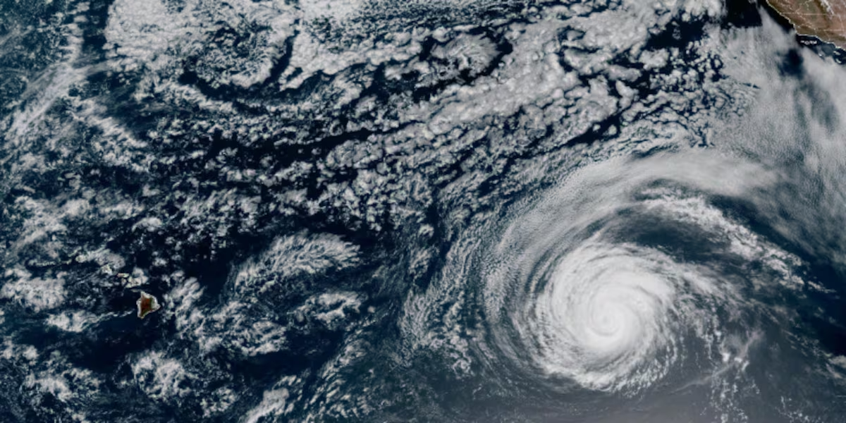
Hurricane Fausto has grown into a Category 2 system over open Pacific water, and forecasters say the storm is on a track that will bring it toward the Hawaiian Islands sometime next week.
The National Hurricane Center in Miami reported Friday that the chance of wind and rainfall effects reaching the islands is climbing. Even so, meteorologists cautioned that it remains far too early to pin down exactly where the storm will go or how strong its influence will be when it arrives.
Where the Storm Sits Now
Fausto is currently a long way from any coastline. As of the latest advisory, the center of the storm was roughly 1,300 miles west of the southern end of Mexico’s Baja California peninsula and about 1,600 miles east of Hilo, Hawaii.
Maximum sustained winds were clocked near 100 mph, placing it comfortably within Category 2 territory on the Saffir-Simpson scale.
That distance is significant for two reasons. It gives residents and emergency managers in Hawaii ample time to prepare, and it also means the forecast track carries considerable uncertainty. Systems traveling across thousands of miles of open ocean have plenty of opportunity to strengthen, weaken, speed up, slow down or shift direction before they matter to anyone on land.
A Threat That Reaches California First
One consequence of Fausto is already heading toward the mainland, and it has nothing to do with wind or rain.
The hurricane center warned that swells generated by the storm could produce dangerous surf and powerful rip currents along parts of southern California. Ocean energy travels far ahead of a storm system, which is why beachgoers can encounter hazardous conditions under a clear blue sky with no weather in sight.
Rip currents are the leading cause of surf-related rescues and drownings in the United States. They form when water pushed onshore by breaking waves funnels back out to sea through a narrow channel, creating a fast-moving current that can pull even strong swimmers away from the beach.
The standard guidance is worth repeating whenever an offshore storm sends swells toward the coast:
- Swim only where lifeguards are on duty
- If caught in a rip current, do not fight it directly toward shore
- Swim parallel to the beach until you exit the current, then angle back in
- Float and conserve energy rather than exhausting yourself against the pull
- Check local surf advisories before entering the water
Elevated swell can persist for several days, often long after the storm generating it has moved on or weakened.
Why Hawaii Watches These Storms Carefully
Hawaii sits in a stretch of the Pacific where hurricanes frequently pass nearby but relatively rarely make direct landfall. Cooler water and wind shear surrounding the islands tend to weaken approaching systems, which has spared the state from many storms that once looked threatening.
That history can breed complacency, and forecasters consistently push back against it. A weakening hurricane can still deliver damaging winds, flooding rainfall, landslides on steep terrain and dangerous coastal surf. The islands’ geography compounds the risk, since mountainous topography can wring enormous rainfall totals out of a passing system and funnel runoff into narrow valleys.
Supply chains present another vulnerability. Nearly everything consumed in Hawaii arrives by ship or plane, so a storm that disrupts ports or airports can create shortages that outlast the weather itself. Emergency officials typically recommend residents maintain longer supply reserves than mainland guidance suggests for that reason.
The Other Storm This Week
Fausto has been spinning up in the Pacific during the same stretch that Tropical Storm Bertha worked its way along the Gulf Coast.
Bertha delivered heavy surf and pockets of flooding across southern Louisiana and parts of Texas as it moved ashore for a second time on Thursday. By late that evening, the hurricane center announced the system had dissipated.
Two named storms operating in different basins simultaneously is not unusual at this point in the calendar. The eastern Pacific and Atlantic seasons overlap through the summer and into autumn, and both basins can produce activity in the same week.
What to Do With a Forecast This Early
When a storm is more than a week from any potential impact, the useful response is preparation rather than alarm.
For anyone in Hawaii, this is the window to review supplies, confirm that flashlights and radios work, refill prescriptions, and know whether your home sits in a flood-prone or coastal inundation zone. Those steps cost little if the storm never arrives and become difficult to complete once a warning is issued.
It is also the moment to be skeptical of dramatic long-range forecast graphics circulating on social media. Individual model runs at this range routinely disagree by hundreds of miles, and a single map showing a direct hit tells you very little about actual probability.
Staying Updated
Track and intensity forecasts will be revised repeatedly over the coming days as Fausto moves west. The National Hurricane Center issues regular advisories, and Hawaii-specific guidance will come from the Central Pacific Hurricane Center once the system crosses into that basin.
The practical advice remains what it always is with a distant storm: watch the official updates, prepare calmly now, and wait for the forecast to tighten before drawing conclusions about what next week will bring.
Author
-
Lucienne Albrecht is Luxe Chronicle’s wealth and lifestyle editor, celebrated for her elegant perspective on finance, legacy, and global luxury culture. With a flair for blending sophistication with insight, she brings a distinctly feminine voice to the world of high society and wealth.