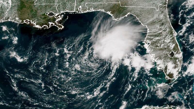
Invest 91L Gulf of Mexico watchers have reason to pay closer attention this weekend. The tropical disturbance sitting in the northern Gulf has seen its development odds climb, and if it organizes enough to earn a name, it would become Tropical Storm Bertha.
The Odds Are Rising
Over the past 24 hours, the chance of tropical development within the next seven days moved from 30 percent to 40 percent.
That is not a dramatic jump, but the direction matters. A system trending upward is one worth tracking rather than dismissing, particularly when it is already sitting over warm water close to populated coastline.
Why It Hasn’t Come Together Yet
Satellite imagery tells the story clearly. Rather than the tight, symmetrical spin that defines a healthy tropical system, 91L looks scattered and disorganized.
The culprit is wind shear — strong winds at different altitudes moving at different speeds and directions, effectively tearing at the storm’s structure faster than it can build one. Right now that shear is cutting straight across the northern Gulf.
For a tropical system to strengthen, it needs to stack vertically, with its circulation aligned from the surface upward. Shear prevents that stacking. The thunderstorms get displaced from the center, and the whole system stays lopsided.
What Forecasters Expect
The system is drifting north over progressively warmer water, which normally favors intensification. But the shear is expected to persist, and that acts as a ceiling.
The current expectation is that 91L will not become a severe or particularly powerful storm.
That said, weak does not mean harmless. A disorganized system can still carry an enormous amount of moisture, and moisture is what produces flooding. Some of the most damaging tropical events on the Gulf Coast have come from storms that never reached impressive wind speeds.
Where It Might Go
Spaghetti models — the collection of individual computer forecast tracks plotted together — are currently clustering along a northward path aimed at the Florida Panhandle and southern Alabama.
Clustering is a good sign for confidence in the general direction. It is not a guarantee about the specifics.
Significant uncertainty remains about the final landfall point, largely because the system is expected to linger in the northern Gulf rather than move decisively. Slow-moving systems are notoriously hard to forecast, since small steering changes translate into large track differences.
Two Scenarios Worth Understanding
Forecasters are essentially watching for the system to break one of two ways.
If it shifts east
Holding the current course toward the Florida Panhandle and the western Florida coast would bring:
- Wind gusts in the 30 to 40 mph range
- Heavy downpours
- Localized storm surge
Those impacts would run through Monday.
If it shifts west
A track that carries the system further west toward New Orleans changes the picture for southeast Louisiana considerably. Rainfall totals there would climb significantly.
That scenario is the one that deserves the closest watch, because southeast Louisiana’s drainage capacity is finite and a slow-moving moisture source parked overhead is the classic setup for street flooding.
Why Rainfall Matters More Than Wind Here
It is worth stepping back from the category-and-wind-speed framing that dominates tropical coverage.
A system like 91L, if it never organizes tightly, distributes its energy differently than a compact hurricane does. Instead of concentrating destructive wind near a small core, it spreads moisture across a wide area and moves slowly.
The result can be prolonged rainfall over the same locations for many hours. Ground saturates, drainage backs up, and flooding develops even without a single gust strong enough to make headlines.
That is the realistic threat profile here, and it is why the eastern-versus-western track question matters so much for planning.
What Coastal Residents Should Do Now
Nothing about this system calls for alarm at this stage. It does call for basic readiness.
Reasonable steps over the next day or two:
- Clear gutters and storm drains near your property
- Move vehicles off low-lying streets if heavy rain is forecast locally
- Check that you have a way to receive weather alerts overnight
- Avoid making assumptions based on the current track, since it may shift
Anyone with plans along the Panhandle, Alabama coast, or southeast Louisiana through Monday should build in flexibility.
The Bottom Line
Invest 91L is a developing situation, not an emergency. Development odds have risen to 40 percent, wind shear is limiting how strong it can get, and the general track points north toward the Panhandle and southern Alabama.
The variable to watch is the east-west wobble. Everything about who gets the heaviest rain depends on it.
Forecast updates will refine the picture as the system either consolidates into Tropical Storm Bertha or stays a disorganized rain producer. Either way, the Gulf Coast should expect a wet stretch through early next week.
Author